Extracted images: Landscaping
Printed revision: February 2004.
Back to source | Original PDF | Image metadata
Original Mistral crops are preserved byte for byte. A crop can be a figure, table, equation, or other visual; no visual content is inferred as a numerical rule. Record and table associations use the same PDF page unless a direct image placeholder is identified. Nearby OCR excerpts are context, not verified captions.
PDF page 3, image 1
Mistral ID: img-0.jpeg. Extraction bundle(s): 2023_BMP_7_Landscaping. Original page | Image file
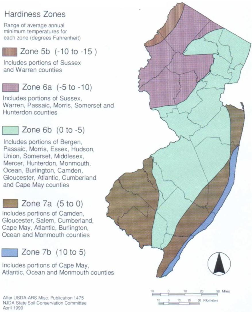
Tables on the same PDF page: Table 7-1: USDA Hardiness Zones for New Jersey
Surrounding OCR excerpt:
|
| --- | --- | --- |
|  Temperate Zone 5 | a | -20 to -15  |
|   |  b | -15 to -10  |
|  Temperate Zone 6 | a | -10 to -5  |
|   |  b | -5 to 0  |
|  Temperate Zone 7 | a | 0 to 5  |
|   |  b | 5 to 10  |

[OCR image]
Figure 7-1: USDA Plant Hardiness Zones' Average Annual Minimum Temperature (New Jersey)

Hardiness Zones

Range of average annual minimum temperatures for each zone (degrees Fahrenheit)

Zone 5b (-10 to -15)

Includes portions of Sussex and Warren counties

Zone 6a (-5 to -10)

Includes portions of Sussex, Warren, Passaic, Morris, Somerset and Hunterdon counties

Zone 6b (0 to -5)

Includes portions of
PDF page 4, image 1
Mistral ID: img-1.jpeg. Extraction bundle(s): 2023_BMP_7_Landscaping. Original page | Image file
Surrounding OCR excerpt:
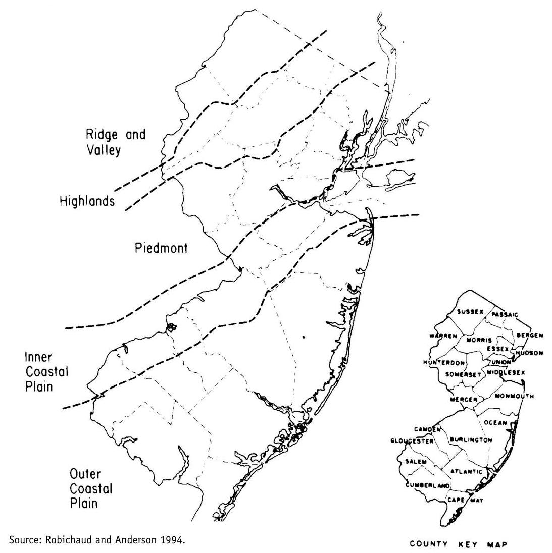
planting guidance. For more detailed information and plant listings, please refer to Plant Communities of New Jersey (Robichaud and Anderson 1994).

Figure 7-2: The Five Physiographic Sections of New Jersey
[OCR image]
PDF page 15, image 1
Mistral ID: img-2.jpeg. Extraction bundle(s): 2023_BMP_7_Landscaping. Original page | Image file
Surrounding OCR excerpt:
ood plain conditions. Hackberry, Pitch Pine, Sheep Fescue, Wildflowers, many native grasses.

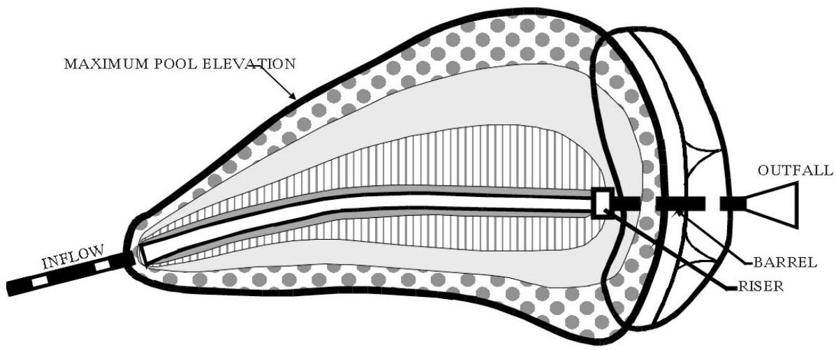
Note: Tree and shrub setback requirements from the dam embankment, riser, and pipes should be strictly followed.

[OCR image]

PLAN VIEW

Source: Adapted from Schueler and Claytor 2000.
PDF page 16, image 1
Mistral ID: img-3.jpeg. Extraction bundle(s): 2023_BMP_7_Landscaping. Original page | Image file
Surrounding OCR excerpt:
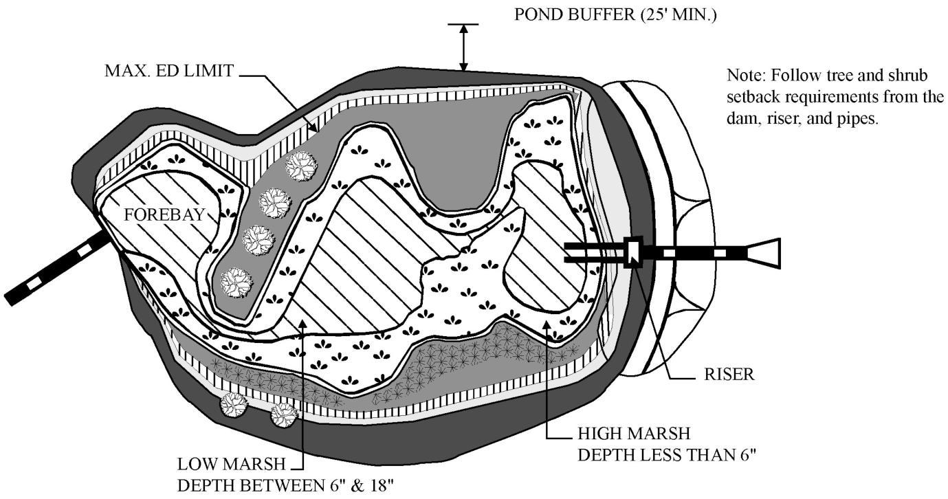
CAPING ZONE 6
(Floodplain) Mostly ornamentals as long as soil drains well, many natives. All species must be able to tolerate floodplain conditions. Hackberry, Pitch Pine, Sheep Fescue, Wildflowers, Grasses

[OCR image]

Source: Adapted from Schueler and Claytor 2000.
PDF page 17, image 1
Mistral ID: img-4.jpeg. Extraction bundle(s): 2023_BMP_7_Landscaping. Original page | Image file
Surrounding OCR excerpt:
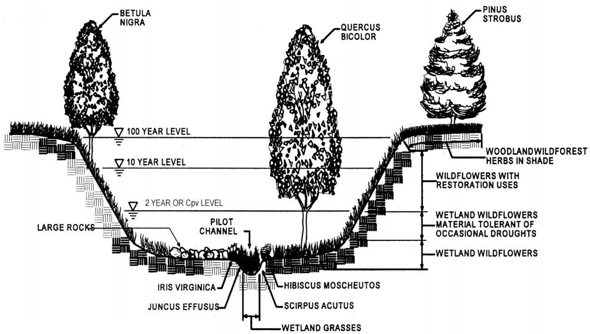
Figure 7-5: Section of a Typical Stormwater Management Detention Pond
[OCR image]
Source: Claytor and Schueler 1997.

## Design Constraints

- Planting buffer strips of at least 20 feet will cause sediments to settle out before reaching the facility, thereby reducing the possibility of clogging.
- Determine areas that will be saturated with water as well as water table depth so that appropriate plants may be selected (hydrology will be similar to bioretention facilities, see Figure 7
PDF page 18, image 1
Mistral ID: img-5.jpeg. Extraction bundle(s): 2023_BMP_7_Landscaping. Original page | Image file
Surrounding OCR excerpt:
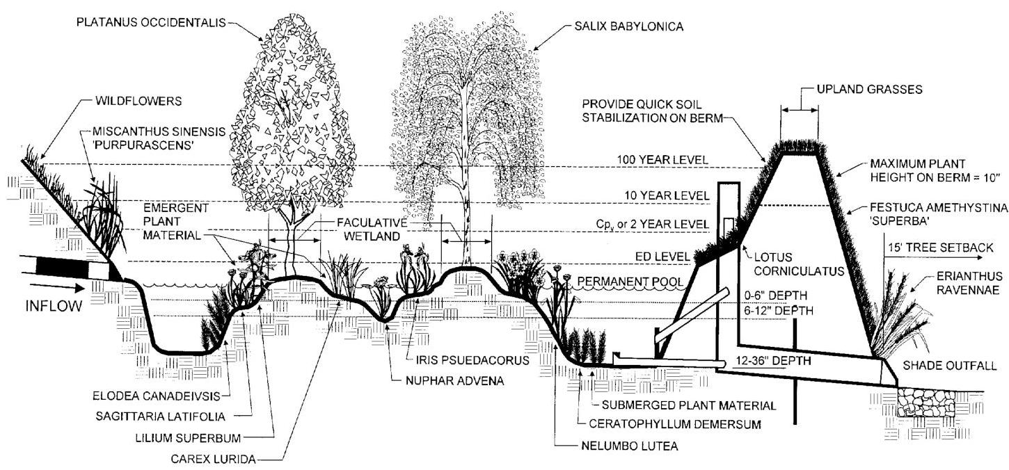
Figure 7-6: Section of Typical Shallow Extended Detention Marsh System
[OCR image]
Source: Claytor and Schueler 1997.
PDF page 20, image 1
Mistral ID: img-6.jpeg. Extraction bundle(s): 2023_BMP_7_Landscaping. Original page | Image file
Tables on the same PDF page: Table 7-4: Planting Soil Characteristics
Surrounding OCR excerpt:
e salts | < = 500 ppm  |
|  Clay | 10 to 25%  |
|  Silt | 30 to 55%  |
|  Sand | 35 to 60%  |
|  Source: Adapted from Schueler and Claytor 2000.  |   |

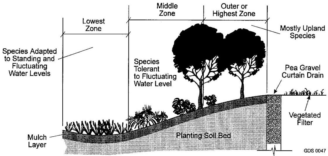
Figure 7-7: Planting Zones for a Bioretention Facility
[OCR image]
Source: Claytor and Schueler 1997.