{"metadata": {"source_document": "NJ BMP", "version_year": "2026", "chapter_subchapter": "Chapter 9.10", "citation": "BMP 2026, Ch 9.10, p. 1", "topic": "Table 1"}, "programmatic_checks": {}, "content_markdown": "# Vegetative Filter Strips (Small-Scale GI)\n\n## Table 1\n\n| N.J.A.C. 7:8 Stormwater Management Rules – Applicable Design and Performance Standards | | |\n| --- | --- | --- |\n| | Green Infrastructure | Yes |\n| | Stormwater Runoff Quantity | Not Allowed |\n| GR | Groundwater Recharge | Not Allowed |\n| % | Stormwater Runoff Quality | 60 - 80% TSS, depending on type of vegetation
See Page 3 |\n| Stormwater Runoff Quality Mechanisms and Corresponding Criteria | |\n| --- | --- |\n| Vegetative Uptake and Filtration | |\n| Minimum Density of Vegetation | 85% |\n| Species Selection | Turf Grass,
Meadow Cover,
Planted Woods or
Existing Forest Areas |\n| Required Length | Minimum Length 25 feet
Maximum Length 100 feet
See Appropriate Chart on Pages 9-11 |\n| Maximum Allowable Slope | See Table on Page 12 |\n| Flow Characteristics | Sheet Flow Only |\n\nSource context and notes:\n\nSource revision: January 2026.\n\n# 9.10 VEGETATIVE FILTER STRIPS\n\n[Figure: img-0.jpeg (original PDF, p. 1)](SOURCE.pdf#page=1)\n\n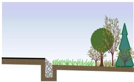\n\nA vegetative filter strip is a stable, evenly graded area that removes pollutants from stormwater runoff through filtration and biological uptake. In order to provide pollutant treatment, runoff must enter and move through the filter strip as sheet flow; therefore, vegetative filter strips must have shallow enough slopes to maintain this flow condition. When designed in accordance with this chapter, the total suspended solid (TSS) removal rate is 60 - 80%, depending on the type of vegetation.\n\n\n| N.J.A.C. 7:8 Stormwater Management Rules – Applicable Design and Performance Standards | | |\n| --- | --- | --- |\n| | Green Infrastructure | Yes |\n| | Stormwater Runoff Quantity | Not Allowed |\n| GR | Groundwater Recharge | Not Allowed |\n| % | Stormwater Runoff Quality | 60 - 80% TSS, depending on type of vegetation
See Page 3 |\n| Stormwater Runoff Quality Mechanisms and Corresponding Criteria | |\n| --- | --- |\n| Vegetative Uptake and Filtration | |\n| Minimum Density of Vegetation | 85% |\n| Species Selection | Turf Grass,
Meadow Cover,
Planted Woods or
Existing Forest Areas |\n| Required Length | Minimum Length 25 feet
Maximum Length 100 feet
See Appropriate Chart on Pages 9-11 |\n| Maximum Allowable Slope | See Table on Page 12 |\n| Flow Characteristics | Sheet Flow Only |\n\n\n\n[Source PDF](SOURCE.pdf#page=1)\n\nOCR images on the cited PDF pages (page association only): [p. 1, image 1](images/page-0001-img-01.jpg)"}
{"metadata": {"source_document": "NJ BMP", "version_year": "2026", "chapter_subchapter": "Chapter 9.10", "citation": "BMP 2026, Ch 9.10, p. 2", "topic": "Table 2"}, "programmatic_checks": {}, "content_markdown": "# Vegetative Filter Strips (Small-Scale GI)\n\n## Table 2\n\n| Type of Vegetation | TSS Removal Rate |\n| --- | --- |\n| Turf Grass | 60% |\n| Meadow Cover | 70% |\n| Planted Woods | 70% |\n| Existing Forest Areas | 80% |\n\nSource context and notes:\n\n# Applications\n\n[Figure: img-1.jpeg (original PDF, p. 2)](SOURCE.pdf#page=2)\n\n\n\nPursuant to N.J.A.C. 7:8-5.2(a)(2), the minimum design and performance standards for groundwater recharge, stormwater runoff quality and stormwater runoff quantity at N.J.A.C. 7:8-5.4, 5.5 and 5.6 shall be met by incorporating green infrastructure in accordance with N.J.A.C. 7:8-5.3.\n\nTo receive credit for the approved 60-80% total suspended solids (TSS) removal rate, vegetative filter strips must be designed to treat the Water Quality Design Storm (WQDS) and in accordance with all of the criteria below. The actual TSS removal rate for a particular vegetative filter strips will depend on the slope, length and type of vegetation in the filter strip. The following table shows the maximum achievable TSS removal rate for each category of vegetation.\n\n\n| Type of Vegetation | TSS Removal Rate |\n| --- | --- |\n| Turf Grass | 60% |\n| Meadow Cover | 70% |\n| Planted Woods | 70% |\n| Existing Forest Areas | 80% |\n\n\n\n[Source PDF](SOURCE.pdf#page=2)\n\nOCR images on the cited PDF pages (page association only): [p. 2, image 1](images/page-0002-img-01.jpg)"}
{"metadata": {"source_document": "NJ BMP", "version_year": "2026", "chapter_subchapter": "Chapter 9.10", "citation": "BMP 2026, Ch 9.10, p. 12", "topic": "Table 3"}, "programmatic_checks": {}, "content_markdown": "# Vegetative Filter Strips (Small-Scale GI)\n\n## Table 3\n\n| Maximum Filter Strip Slope (%) | | | | |\n| --- | --- | --- | --- | --- |\n| Soil Type | Hydrologic Soil Group | Turf Grass | Meadow Cover or Planted Woods | Existing Forest Areas |\n| Sand | A | 7 | 7 | 5 |\n| Sandy Loam | A | 8 | 8 | 7 |\n| Loam, Silt Loam | B | 6.9 | 8 | 8 |\n| Sandy Clay Loam | C | 5.8 | 8 | 8 |\n| Clay Loam, Silty Clay, Clay | D | 4.6 | 6.5 | 8 |\n\nSource context and notes:\n\n# Vegetative Filter Strips (Small-Scale GI)\n\nSource revision: January 2026.\n\n# Maximum Filter Strip Slope\n\nThe maximum allowable slope for a vegetative filter strip is determined by the contributory drainage area soils and the type of vegetation within the filter strip. Both onsite soil investigations and the Web Soil Survey can be used to determine the soils types; if more than one type of soil exists, the soil type with the smallest particle size is used in the filter strip's design. If the post-development contributory drainage area is impervious, the pre-development soil type is used. Once the soil type is determined, the chart below is used to determine the maximum allowable slope for a given vegetative cover. It should be noted these maximums correspond to the slopes shown for each of the three curves in the five preceding charts.\n\n\n| Maximum Filter Strip Slope (%) | | | | |\n| --- | --- | --- | --- | --- |\n| Soil Type | Hydrologic Soil Group | Turf Grass | Meadow Cover or Planted Woods | Existing Forest Areas |\n| Sand | A | 7 | 7 | 5 |\n| Sandy Loam | A | 8 | 8 | 7 |\n| Loam, Silt Loam | B | 6.9 | 8 | 8 |\n| Sandy Clay Loam | C | 5.8 | 8 | 8 |\n| Clay Loam, Silty Clay, Clay | D | 4.6 | 6.5 | 8 |\n\n\n# How to Determine Filter Strip Length for a Given Slope\n\nThe following example illustrates how to use the charts to determine the required vegetative filter strip length:\n\nExample 2: Compute the required filter strip length assuming the strip is to be vegetated with turf grass. A vegetative filter strip with a uniform 5% slope is proposed to treat the stormwater runoff from a contributory drainage area consisting of a paved parking lot. Stormwater runoff enters the filter strip as sheet flow. The maximum sheet flow length across the parking lot does not exceed 100 feet. The soil type in the contributory drainage area is silt loam.\n\n[Source PDF](SOURCE.pdf#page=12)"}