Chapter 11.4: Sand Filters With Underdrain (Non-GI)
Printed revision: January 2026.
Original PDF | Structured records | Tables | Back to index
11.4 SAND FILTERS WITH UNDERDRAINS (NON-GI)
Figure: img-0.jpeg (original PDF, p. 1)
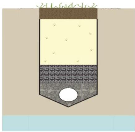
A sand filter with underdrain is a stormwater management system designed to maximize the removal of pollutants from stormwater. It consists of a pre-treatment zone and a treatment zone, which includes the sand bed and the underlying components. Pollutants are treated through settling, filtration, and adsorption by the sand bed. The total suspended solids (TSS) removal rate is 80%. However, sand filters with underdrains can only be used to address the quantity control aspects of development and stormwater runoff water quality when a waiver or variance from N.J.A.C. 7:8-5.3 is granted as they are not considered to be green infrastructure.
| N.J.A.C. 7:8 Stormwater Management Rules – Applicable Design and Performance Standards | ||
|---|---|---|
| Green Infrastructure | Not Allowed | |
| Stormwater Runoff Quantity | Only with a waiver or variance from N.J.A.C. 7:8-5.3 | |
| GR | Groundwater Recharge | Not Allowed |
| % | Stormwater Runoff Quality | Only with a waiver or variance from N.J.A.C. 7:8-5.3, 80% TSS |
| Stormwater Runoff Quality Mechanisms and Corresponding Criteria | ||
| --- | --- | |
| Settling | ||
| Storage Volume | Entire Water Quality Design Storm Volume | |
| Filtration | ||
| Sand bed minimum thickness | 18 inches | |
| Maximum storage above sand bed | 24 inches | |
| Maximum design permeability rate of sand bed | 2 inches/hour | |
| Minimum topsoil permeability rate, if using optional vegetative cover | ≥ 200% the hydraulic head loss of the underdrain |
Introduction
A sand filter with underdrain is a stormwater management facility that uses sand to filter particles and particle-bound constituents from runoff. Stormwater runoff entering the sand filter is first conveyed through the pretreatment zone where trash, debris and coarse sediment are removed. Pollutant removal occurs solely in the sand bed through the processes of settling, filtration and adsorption. Treated stormwater then passes through the treatment zone and out of the system via the underdrain and the outlet pipe. For information on sand filters designed to infiltrate into the subsoil, refer to Chapter 9.9: Small-scale Sand Filters for infiltration sand filters with a contributing drainage area less than or equal to 2.5 acres in compliance with Table 5-1 in N.J.A.C. 7:8-5.2(f) or Chapter 10.3: Sand Filters (Large-scale GI) for larger sand filters compliant with Table 5-2.
Sand filters with underdrains are better suited for regulated motor vehicle surfaces with high TSS, heavy metals and hydrocarbon loadings, e.g., roads, driveways, drive-up lanes, parking lots and urban areas. They are not recommended for use in pervious drainage areas where high sediment loads and organic material can clog the sand bed; where such loadings cannot be avoided, pretreatment is recommended.
Only with a waiver or variance from N.J.A.C. 7:8-5.3 may a sand filter with underdrain, designed in accordance with this chapter, be used to satisfy the standards for stormwater runoff quantity and quality, since this BMP does not meet the definition of green infrastructure.
Sand filters with underdrains must have a maintenance plan and must be reflected in a deed notice recorded in the county clerk's office to prevent alteration or removal.
Applications
Figure: img-1.jpeg (original PDF, p. 2)

Only if a waiver or variance form the green infrastructure requirements of N.J.A.C. 7:8-5.3 is obtained may sand filters with underdrains that are designed to convey storm events larger than the Water Quality Design Storm (WQDS) be used to meet the stormwater runoff quantity requirements. Additionally, regardless of the design storm chosen, all sand filters with underdrains must be designed for stability and capacity in accordance with the Standards for Soil Erosion and Sediment Control in New Jersey, as required by N.J.A.C. 7:8 Stormwater Management rules.
Only if a waiver or variance from the green infrastructure requirement of N.J.A.C. 7:7-5.3 is obtained may sand filters with underdrains be awarded a TSS removal rate of 80%. To merit for the approved TSS removal rate of 80%, sand filters with underdrains must treat the stormwater runoff volume generated by the WQDS and be designed in accordance with all of the design criteria below.
Design Criteria
Basic Requirements
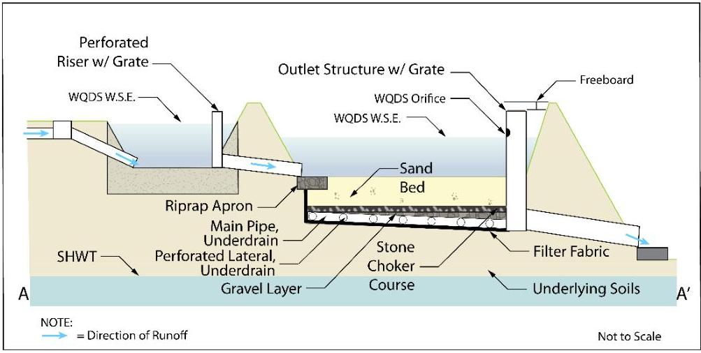
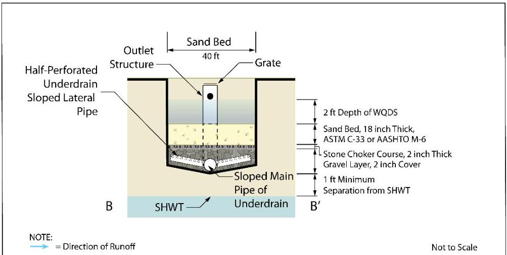
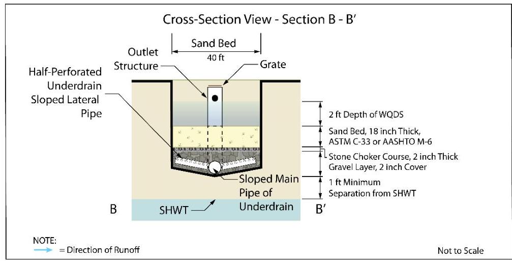
Sand filters with underdrains are generally constructed as off-line systems. In off-line sand filters with underdrains, most or all of the runoff generated by storms larger than the Water Quality Design Storm (WQDS) bypasses the sand filter with underdrain through an upstream diversion; this reduces the size of the required sand filter with underdrain overflow, the sand filter with underdrain's long-term pollutant loading, associated maintenance and the threat of erosion and scour caused by larger storm inflows. Sand filters with underdrains, however, may also be constructed as on-line systems. On-line sand filters with underdrains receive upstream runoff from all storm events; they provide treatment for the WQDS, and they convey the runoff from larger storms through an overflow. These on-line systems store and attenuate the larger storm events and provide runoff quantity control; in such systems, the invert of the lowest quantity control outlet is set at or above the maximum water surface of the WQDS. The following illustrations depict the basic components of sand filters with underdrains and include an outlet structure designed to attenuate flow produced by storms larger than the WQDS.
Figure: img-2.jpeg (original PDF, p. 3)
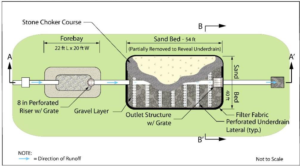
Plan View – Sand Filter with Underdrain
Profile View – Sand Filter with Underdrain
Figure: img-3.jpeg (original PDF, p. 4)
Cross-section View – Sand Filter with Underdrain
Figure: img-4.jpeg (original PDF, p. 4)
All of the following design criteria must all be met in order to receive the 80% TSS removal rate for this BMP. It is critical that all sand filters with underdrains are designed in accordance with these criteria in order to ensure proper operation, to maximize the functional life of the system and to ensure public safety.
Pretreatment
As with all other best management practices, pretreatment can extend the functional life and increase the pollutant removal capability of a sand filter with underdrain by reducing incoming velocities and capturing coarser sediments.
- Pretreatment is a requirement for all sand filters.
- Any roof runoff may be pretreated by leaf screens, first flush diverters or roof washers. For details of these pretreatment measures, see Pages 5 and 6 of Chapter 9.1: Cisterns.
☐ This pretreatment requirement for roof runoff can be waived by the review agency if the building in question has no potential for debris and other vegetative material to be present in the roof runoff. For example, a building that is significantly taller than any surrounding trees and does not have vegetative roof should not need the pretreatment. However, in making this determination, the review agency must consider the mature height of any surrounding trees.
- Pretreatment may consist of a forebay or any of the BMPs found in Chapters 9 or 11..
-
There is no adopted TSS removal rate associated with forebays; therefore, their inclusion in any design should be solely for the purpose of facilitating maintenance. Forebays can be constructed of earthen materials, riprap or concrete and, in each case, must comply with the following requirements:
-
The forebay must be designed to prevent scour of the receiving basin by outflow from the forebay.
- The forebay should provide a minimum storage volume of 10% of the volume generated by the Water Quality Design Storm (WQDS) and be sized to hold the sediment volume expected between clean-outs.
- The forebay should fully drain within nine hours in order to facilitate maintenance and to prevent mosquito issues. Under no circumstances should there be any standing water in the forebay 72 hours after a precipitation event.
- Surface forebays must meet or exceed the sizing for preformed scour holes in the Standard for Conduit Outlet Protection in the Standards for Soil Erosion and Sediment Control in New Jersey for a surface forebay.
- The recommended Minimum Surface Area (sf) = 59 x Inflow (cfs).
-
If a concrete forebay is utilized, it must have at least two weep holes to facilitate low level drainage.
-
When using a structural BMP for pretreatment, it must be designed in accordance with the design requirements outlined in the respective chapter. For additional information on the design requirements of each structural BMP, refer to the appropriate chapter in this manual.
Inflow Drainage Area Limitations
- The upstream inflow drainage area must be completely stabilized prior to sand filter use.
Limitations on the Use of Topsoil and Vegetation
- If vegetation is used above the sand bed, the permeability of the topsoil must be at least twice the hydraulic head loss of the underdrain.
Storage Volume
- The system must have sufficient storage volume to contain the volume of stormwater runoff generated by the WQDS without overflow.
- Under no circumstances may exfiltration (infiltration into the soil below the system) be included in the routings for stormwater runoff quantity control for any sand filter system designed with an underdrain.
Placement of Energy Dissipative Material
- The use of energy dissipative material, e.g., riprap, to prevent scouring of the receiving sand in a sand filter with underdrain should be limited to the area directly under the inflow.
Sand Bed
The thickness and character of the bed must provide adequate pollutant removal.
- Minimum thickness: 18 inches.
- Maximum storage above the sand bed: 24 inches.
- The sand must meet the specifications for clean, medium-aggregate concrete sand in accordance with AASHTO M-6 or ASTM C-33, as certified by a professional engineer licensed in the State of New Jersey.
- The maximum design permeability rate of the sand bed is 2 inches/hour and must be verified prior to installation.
- When using the 2 inches/hour permeability rate, a design drain time of 36 hours must be used.
Stone Choker Course
- This layer must be between 1 and 2 inches.
- The stone in this layer must meet the specifications for clean, coarse aggregate in accordance with AASHTO No. 57.
Gravel Layer
- The gravel in this layer must be clean, washed aggregate material whose size is appropriate for the anticipated weight of the system, including the weight of the stormwater runoff from the largest design storm and any anticipated maintenance loads, and must provide a minimum of 2 inches of cover both above and below the underdrain network.
- To ensure proper system operation, the gravel layer must have infiltration and conveyance rates at least twice as fast as the design flow from the sand bed.
Underdrain Network
- The underdrain network must be constructed of perforated pipe of sufficient size to resist crushing.
- The underdrain network must connect to a downstream location that is easily accessible for inspection and maintenance.
- To ensure proper system operation, the perforated underdrain network must have infiltration and conveyance rates at least twice as fast as the design flow from the sand bed.
Filter Fabric
- Filter fabric is required along the sides and the bottom of the system to prevent the migration of fines from the surrounding soil.
Permeability
The following specifications apply to the permeability rates of the topsoil in systems designed with the optional vegetative cover, the sand bed, the stone choker course, the gravel layer and the perforated underdrain network.
- The testing of all permeability rates must be consistent with Chapter 12: Soil Testing Criteria in this manual.
- Since the actual permeability rate may vary from soil testing results and may decrease over time, a factor of safety of 2 must be applied to the tested permeability rate to determine the design permeability rate. For example, if the tested permeability rate is 4 inches/hour, then the design rate would be 2 inches/hour. The design rate would then be used to compute the system's Water Quality Design Storm drain time.
- Post-construction testing of the system must be performed on the as-built sand filter in accordance with "Section 4: Construction and Post-Construction Oversight and Soil Hydraulic Conductivity Testing," located in Chapter 12: Soil Testing Criteria of this manual.
Separation from the Seasonal High Water Table
- The seasonal high water table (SHWT) must be at least 1 foot below the bottom of the sand filter with underdrain, including all network components and aggregate below the underdrain network.
- The SHWT must be located in accordance with "Subsection 1d: Seasonal High Water Table (SHWT) Location" of Chapter 12 of this manual.
Outlet Structure
- For systems designed with an outlet structure, trash racks must be installed at the intake to the outlet structure. They must also be designed to avoid acting as the hydraulic control for the system, and they must meet the following criteria, as required by N.J.A.C. 7:8-5.2(i)2 and 6.2(a):
☐ Parallel bars spaced at 1-inch intervals, up to the elevation of the WQDS; ☐ Minimum bar spacing: 1 inch, for elevations in excess of the WQDS;
Maximum bar spacing: 1/3 the diameter of the orifice or 1/3 the width of weir, with a maximum spacing of 6 inches, for elevations in excess of the WQDS; Maximum average velocity of flow through clean rack: 2.5 feet/second, under full range of stage and discharge, computed on the basis of the net area of opening through rack; Constructed of rigid, durable and corrosion-resistant material; and Designed to withstand a perpendicular live loading of 300 lbs./sf.
Figure: img-5.jpeg (original PDF, p. 8)
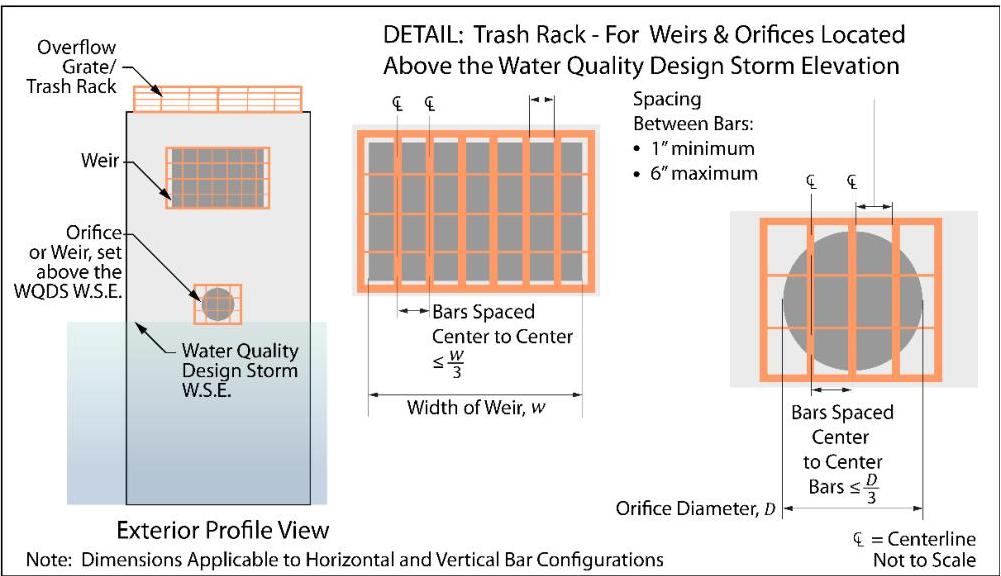
- An overflow grate is designed to prevent obstruction of the overflow structure. If an outlet structure has an overflow grate, the grate must comply with the following requirements:
The overflow grate must be secured to the outlet structure but removable for emergencies and maintenance; The overflow grate spacing must be no greater than 2 inches across the smallest dimension; and The overflow grate must be constructed of rigid, durable and corrosion resistant material and designed to withstand a perpendicular live loading of 300 lbs./sf.
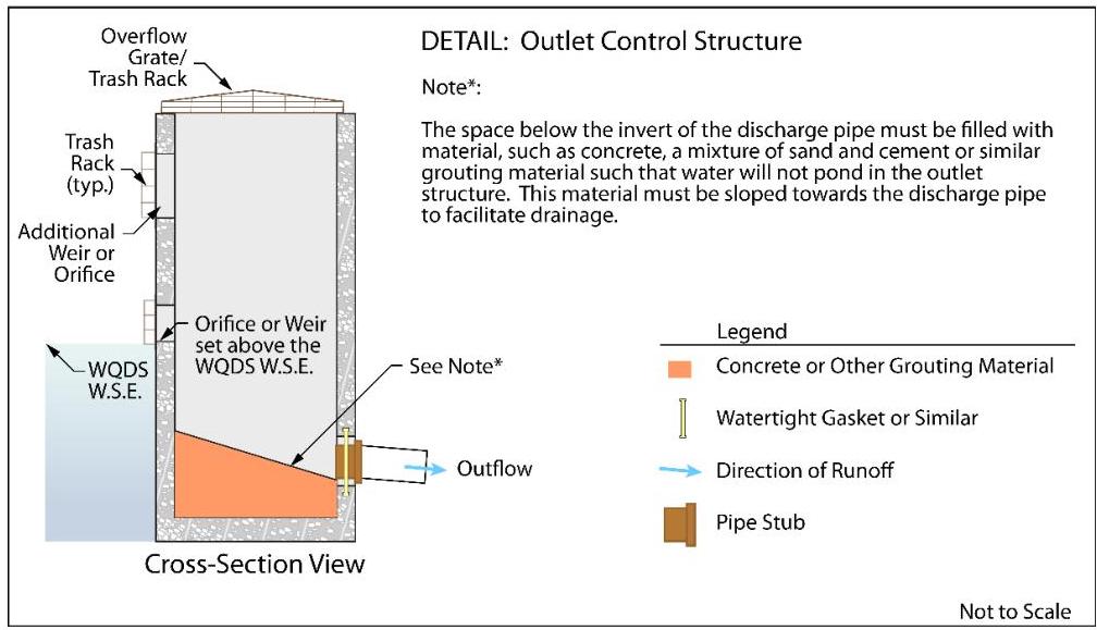
- The space below the invert of the discharge pipe must be filled with material, such as concrete, a mixture of sand and cement, or similar grouting material, such that water will not pond in the outlet structure. This material must be sloped towards the discharge pipe to facilitate drainage, as shown in the detail on the following page.
Figure: img-6.jpeg (original PDF, p. 9)
- Any flow control device, such as an orifice, weir, grate or perforated pipe, at the outlet of the stormwater management measures shall be designed to prevent the clogging of the flow control device while achieving the design and performance standards at N.J.A.C. 7:8-5.4, 5.5 and 5.6.
- Blind connections to down-gradient facilities are prohibited. Any connection to down-gradient stormwater management facilities must include access points such as inspection ports and manholes, for visual inspection and maintenance, as appropriate, to prevent blockage of flow and ensure operation as intended. All entrance points must adhere to all State, County and municipal safety standards such as those for confined space entry.
- In instances where the lowest invert in the outlet or overflow structure is below the flood hazard area design flood or tide elevation in a down-gradient waterway or stormwater collection system, the effects of tailwater on the hydraulic design of the overflow systems, as well as any stormwater quantity control outlets must be analyzed. Two methods to analyze tailwater are:
☐ A simple method entails inputting flood elevations for the 2-, 10- and 100-year events as static tailwater during routing calculations for each storm event. These flood elevations are either obtained from a Department flood hazard area delineation or a FEMA flood hazard area delineation that includes the 100-year flood elevation or derived using a combination of NRCS hydrologic methodology and a standard step backwater analysis or level pool routing, where applicable. In areas where the 2-year or 10-year flood elevation does not exist in a FEMA or Department delineation, it may be interpolated or extrapolated from the existing data. If this method demonstrates that the requirements of the regulations are met with the tailwater effect, then the design is acceptable. If the analysis shows that the requirements are not met with the tailwater effects, the detailed method below can be used or the BMP must be redesigned.
☐ A detailed method entails the calculation of hydrographs for the watercourse during the 2-, 10-, and 100-year events using NRCS hydrologic methodology. These hydrographs are input into a computer program to calculate rating curves for each event. Those rating curves are then input as a dynamic tailwater during the routing calculations for each of the 2-, 10- and
100-year events. This method may be used in all circumstances; however, it may require more advanced computer programs. If this method demonstrates that the requirements of the regulations are met with the tailwater effect, then the design is acceptable. If the analysis shows that the requirements are not met with the tailwater effects, the BMP must be redesigned.
Safety
- All sand filters must be designed to safely convey overflows to down-gradient drainage systems. The design of the overflow structure must be sufficient to provide safe, stable discharge of stormwater runoff in the event of an overflow. Safe and stable discharge minimizes the possibility of erosion and flooding in down-gradient areas. Therefore, discharge in the event of an overflow must be consistent with the current version of Standards for Off-Site Stability found in the Standards for Soil Erosion and Sediment Control in New Jersey, as required by N.J.A.C. 7:8. Sand filters that are classified as dams under the NJDEP Dam Safety Standards at N.J.A.C. 7:20 must meet the overflow requirements under these regulations. Overflow capacity can be provided by a hydraulic structure, such as a weir or orifice, or a surface feature, such as a swale or open channel as site conditions allow.
Drain Time
- The drain time is determined by the hydraulic capacity of the underdrain, the permeability of the sand bed and the permeability of any additional material above it.
- The volume of stormwater runoff generated by the WQDS must fully drain through the sand filter system within 72 hours, based on the design permeability rate. Storage in excess of this time can render the system ineffective and may result in anaerobic conditions, odor, and both stormwater quality and mosquito breeding issues.
- When designing an underdrained sand filter, a design drain time of 36 hours and a sand bed permeability rate of 2 inches/hour must be used.
Construction Specifications
- The use of the sand filter system with underdrain for sediment control during construction is discouraged; however, when unavoidable, excavation for the sediment basin should be at least 2 feet above the final design elevation of the basin bottom.
- Basin excavation and sand placement should be performed with equipment placed outside of the basin bottom whenever possible. However, in circumstances where this is unavoidable, light earth moving equipment with oversized tires or tracks should be utilized.
- The excavation for the sand filter bottom should only occur after all construction within its drainage area is completed and the drainage area is stabilized. If construction of the sand filter cannot be delayed, berms should be placed around the perimeter of the sand filter during all phases of construction, diverting all flows away from the filter. The berms should not be removed until all construction within the drainage area is completed and the area is stabilized.
- Once the excavation is completed, the floor of the sand filter must be deeply tilled with a rotary tiller or disc harrow and smoothed over with a leveling drag, or equivalent grading equipment.
- Once both the sand filter with underdrain and its drainage area are stabilized, the infiltration rate of the sand bed must be retested to ensure that the design permeability rate is the same as the as-built permeability rate.
Designing A Sand Filter with Underdrain
The example below illustrates how to design a sand filter with underdrain to treat the runoff generated by the Water Quality Design Storm. The following parameters apply:
| Inflow Drainage Area = | 50,000 sf of motor vehicle surface |
|---|---|
| Pavement NRCS Curve Number (CN) = | 98 |
| Sand Bed Depth = | 18 in |
| Maximum Design Permeability of Sand Bed = | 2 in/hr |
| WQDS Depth = | 24 in = 2 ft |
Step 1: Runoff Calculations
Using the NRCS method described in National Engineering Handbook, Part 630 (NEH) and discussed in Chapter 5, the volume of runoff produced by the WQDS was calculated to be 4,310 cf based upon an NRCS Curve Number (CN) of 98 for asphalt.
Step 2: Forebay Sizing
The forebay must be sized to hold 10% of the Water Quality Design Storm volume, which results in a volume of 431 cf. Assuming the depth of water in the forebay is equal to be 1 foot, a rectangular forebay with a width of 20 feet and a length of 22 feet will provide adequate storage volume. However, in order to facilitate drainage, the water surface elevation in the forebay must be greater than the water surface elevation in the sand filter; in addition, the perforations in the riser pipe must be designed to ensure that the forebay will drain within 9 hours. A grate or trash rack should be installed on the top of the riser to keep floatables from entering the riser pipe during large storm events.
Step 3: Preliminary Shape and Size of the Sand Filter with Underdrain
A rectangular shape sand filter that has a maximum 2 feet of water during WQDS is selected. The surface area is calculated as follows:
$$ \text{Surface Area} = \frac{4,310\ \text{cf}}{(2\ \text{ft})} = 2,155\ \text{sf} $$
The width is assumed to be 40 feet and the length is 54 feet.
Step 4: Estimated Drain Time Calculation
Since there is no infiltration into the subsoil, the limiting factor in the drain time calculation is the permeability rate of the sand bed.
$$ \text{Drain Time} = \frac{\text{Water Quality Design Storm Runoff Volume}}{\text{System Infiltration Area} \times \text{Sand Bed Design Permeability Rate}} $$
$$ \text{Drain Time} = \frac{\text{Maximum Runoff Depth}}{\text{Sand Bed Design Permeability Rate}} = \frac{24 \text{ in}}{2 \text{ in/hr}} = 12 \text{ hr} $$
Since this is less than the allowable maximum drain time of 72 hours, the sand filter with underdrain system appears, at this stage, to be sized correctly to meet the drain time requirements.
Step 4: Overflow Configuration
The sand filter system in this example is an on-line system. On-line systems receive runoff from all storms events, and they convey the runoff from larger storms through an overflow, which, in this example, consists of a berm and an overflow riser. The orifice in the riser is set at an elevation 2 ft above the surface of the soil bed; this design allows the accumulation of runoff up to the WQDS elevation to infiltrate through the sand layer and stone choker course for collection and discharge via the underdrain system; excess runoff discharges through the overflow pipe, which is fitted with a debris cap to protect the opening from becoming clogged with vegetative matter and trash.
Step 5: Underdrain Design
To ensure that the underdrain does not provide the hydraulic control for the system, the pipe network must be designed with conveyance rates at least twice as fast as the design flow rate through the sand layer. Additionally, the pipes must be sloped for complete drainage. The required clearances within the gravel layer must also be provided.
Step 6: Check Separation from SHWT
The vertical distance between the lowest elevation of the gravel layer and the SHWT must be checked to ensure it meets the minimum 1 ft separation requirement.
Step 7: Refinements to the Design
The illustrations on the following page show this sand filter with underdrain system in plan, profile and cross sectional views. In this example, an additional vertical space above the outflow riser, although not required, is included. This additional vertical space is intended to ensure that the swale does not flood the roadway in the event that debris partially clogs the cap on the overflow riser. This additional space does not increase the volume of runoff infiltrated, as the opening in the outflow riser directs excess runoff to the down-gradient collection system. The overall size of the sand filter system in this example includes end berms as transition areas to the existing grade elevation to account for this additional depth.
Figure: img-7.jpeg (original PDF, p. 13)
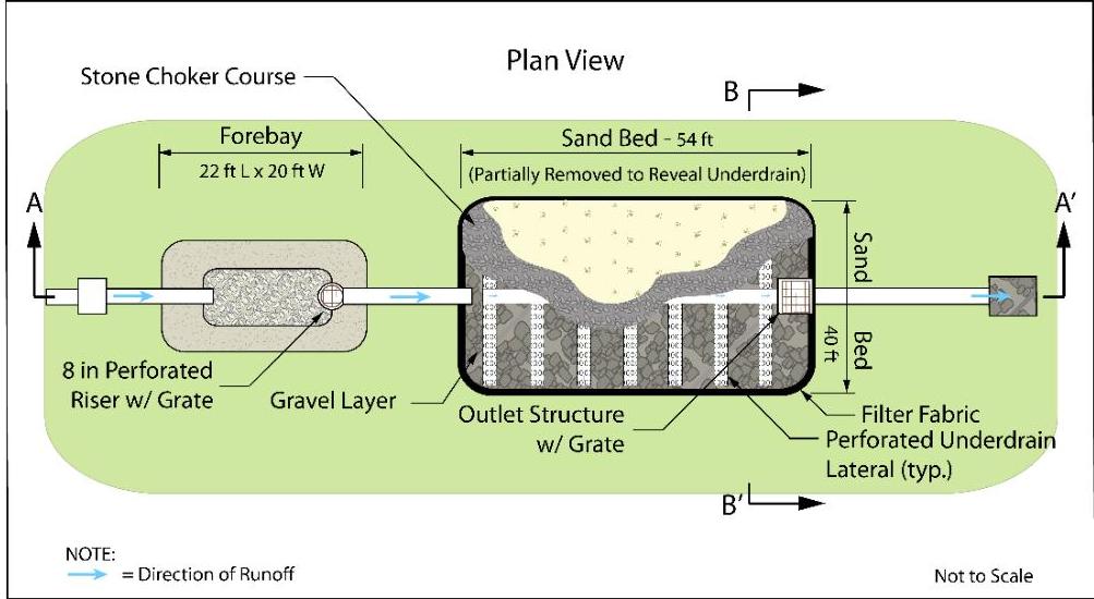 Example - Sand Filter System with Underdrain
Figure: img-8.jpeg (original PDF, p. 13)
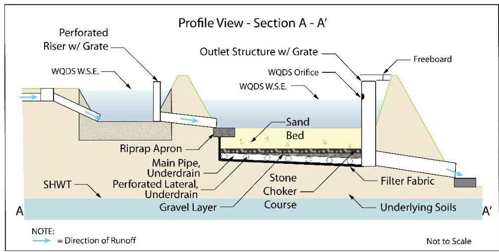
Figure: img-9.jpeg (original PDF, p. 13)
Considerations
The following should be considered when utilizing a sand filter to treat stormwater runoff.
Optional Vegetative Cover
- Vegetation may only be turf grass; however, the use of turf grass does not allow the sand filter with underdrain to be considered to be green infrastructure because the turf grass does not provide treatment of the stormwater through filtration, which would be required to meet the definition of green infrastructure at N.J.A.C. 7:8-1.2.
- The permeability rate of the topsoil, if using the optional vegetated surface, must be twice the design permeability rate of the sand bed.
Maintenance
Regular and effective maintenance is crucial to ensure effective sand filter with underdrain performance; in addition, maintenance plans are required for all stormwater management facilities associated with a major development. There are a number of required elements in all maintenance plans, pursuant to N.J.A.C. 7:8-5.8; these are discussed in more detail in Chapter 8: Maintenance and Retrofit of Stormwater Management Measures. Furthermore, maintenance activities are required through various regulations, including the New Jersey Pollutant Discharge Elimination System (NJPDES) Rules, N.J.A.C. 7:14A. Specific maintenance requirements for sand filter systems are presented below; these requirements must be included in the sand filter's maintenance plan.
General Maintenance
- All structural components must be inspected, at least once annually, for cracking, subsidence, spalling, erosion and deterioration.
- Components expected to receive and/or trap debris and sediment must be inspected for clogging at least twice annually, as well as after every storm exceeding 1 inch of rainfall.
- Sediment removal should take place when all runoff has drained from the sand bed and the sand bed is dry.
- Disposal of debris, trash, sediment and other waste material must be done at suitable disposal/recycling sites and in compliance with all applicable local, state and federal waste regulations.
- Access points for maintenance are required on all sand filters with underdrains; these access points should be clearly identified in the maintenance plan. In addition, any special training required for maintenance personnel to perform specific tasks should be included in the plan.
Vegetated Areas
- In sand filters with underdrains with turf grass surface layers, bi-weekly inspections are required when establishing/restoring vegetation.
- A minimum of one inspection during the growing season and one inspection during the non-growing season is required to ensure the health, density and diversity of the vegetation.
- Mowing/trimming of vegetation must be performed on a regular schedule based on specific site conditions; perimeter grass should be mowed at least once a month during growing season.
- Vegetative cover must be maintained at 85%; damage must be addressed through replanting in accordance with the original specifications.
- Vegetated areas must be inspected at least once annually for erosion, scour and unwanted growth; any unwanted growth should be removed with minimum disruption to the remaining vegetation.
- All use of fertilizers, pesticides, mechanical treatments and other means to ensure optimum vegetation health must not compromise the intended purpose of the sand filter.
Drain Time
- The sand bed must be inspected at least twice annually to determine if the permeability of the bed has decreased.
- The approximate drain time for the maximum design storm runoff volume below the top of the sand bed must be indicated in the maintenance manual.
- If the actual drain time is significantly different from the design drain time, the components that could provide hydraulic control must be evaluated and appropriate measures taken to return the sand filter to minimum and maximum drain time requirements.
- If the sand filter fails to drain within 72 hours, corrective action must be taken, up to and including the replacement of the upper layers of the sand bed. In addition, the anticipated frequency of this replacement must be indicated in the maintenance manual.
References
Claytor, R. and T. Schueler. December 1996. Design of Stormwater Filtering Systems. The Center for Watershed Protection. Ellicott City, MD.
Horner, R.R., J.J. Skupien, E.H. Livingston and H.E. Shaver. August 1994. Fundamentals of Urban Runoff Management: Technical and Institutional Issues. In cooperation with U.S. Environmental Protection Agency. Terrene Institute, Washington, DC.
Livingston, E.H., H.E. Shaver, J.J. Skupien and R.R. Horner. August 1997. Operation, Maintenance, & Management of Stormwater Management Systems. In cooperation with U.S. Environmental Protection Agency. Watershed Management Institute. Crawfordville, FL.
Maryland Department of the Environment. 2000. Maryland Stormwater Design Manual – Volume I – Stormwater Management Criteria. Water Management Administration. Baltimore, MD.
New Jersey Department of Agriculture. November 1999. Standards for Soil Erosion and Sediment Control in New Jersey. State Soil Conservation Committee. Trenton, NJ.
New Jersey Department of Environmental Protection and Department of Agriculture. December 1994. Stormwater and Nonpoint Source Pollution Control Best Management Practices.
Ocean County Planning and Engineering Departments and Killam Associates. June 1989. Stormwater Management Facilities Maintenance Manual. New Jersey Department of Environmental Protection. Trenton, NJ.
Schueler, T.R., P.A. Kumble and M. Heraty. March 1992. A Current Assessment of Urban Best Management Practices. Metropolitan Washington Council of Governments. Washington, DC.
Extracted images
Browse 10 distinct Mistral image crops | Image provenance and record associations